Who · what · when · why
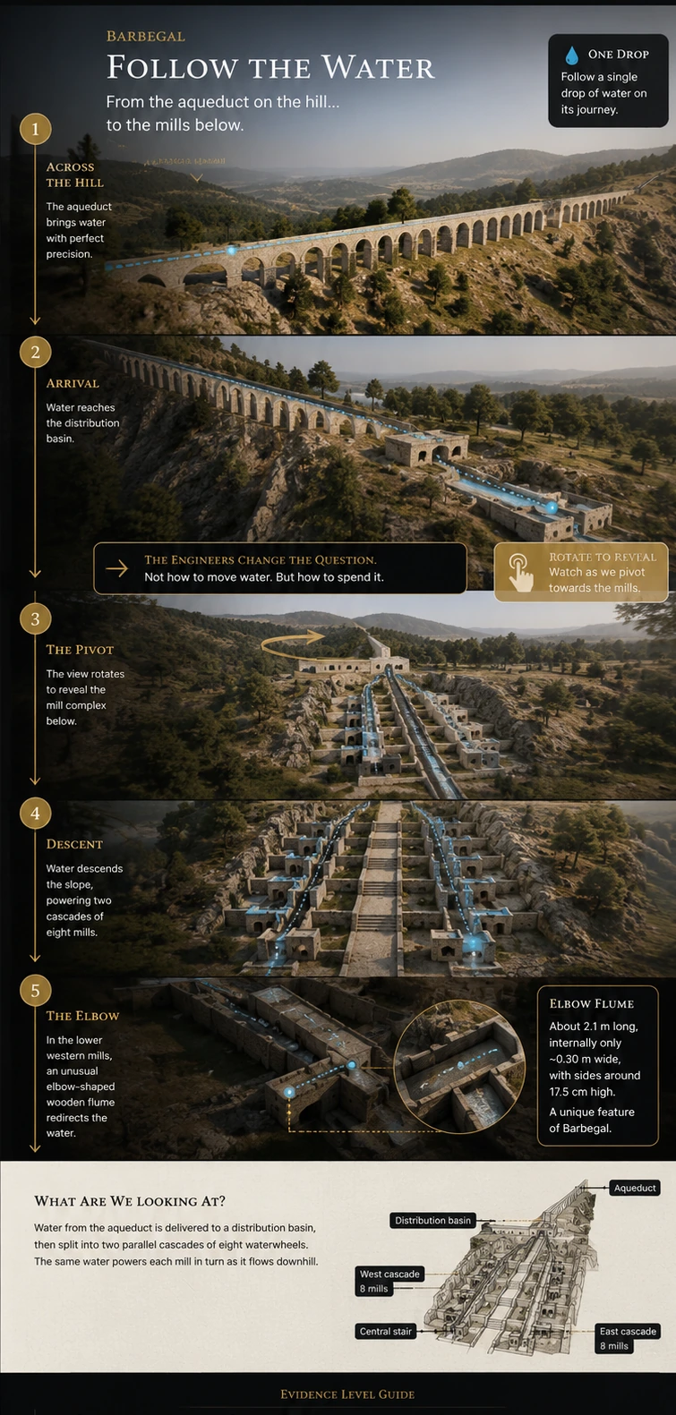
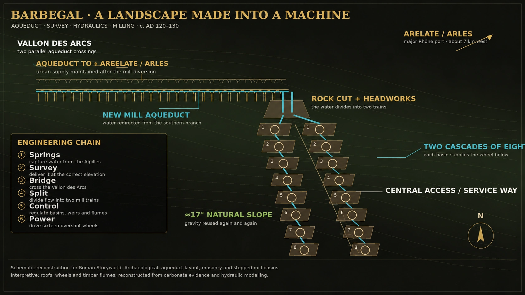
On the southern side of the Alpilles, about seven kilometres east of Roman Arelate (Arles), engineers in the early second century AD redirected part of an established aqueduct system towards a steep limestone ridge. At its crest the water divided into two channels and descended through sixteen mills arranged as two cascades of eight.[1]
The builders are unnamed. The owner is unknown. What survives instead is the engineering: a reconfigured urban water network, a new aqueduct crossing, carefully stepped wheel basins, masonry chambers and mineral casts of the timber machinery itself.
Claim
Was Barbegal a collection of mills, or one integrated hydraulic machine?
Ancient knowledge
Use Roman and Greek surveying evidence to ask what had to be measured before construction began.
Archaeology
Read the aqueducts, bridge masonry, wheel pits and carbonate casts of lost timber.
Competing interpretations
Test output, purpose, ownership and the modern language of “factory” and “industrial”.
Evidence audit
Separate measured dimensions and mineral traces from hydraulic reconstruction and economic inference.
What survives
A landscape in which gravity was deliberately organised into repeatable mechanical work.
01
The claim
Barbegal was not a mill beside an aqueduct
The familiar description—“sixteen Roman watermills”—is true but incomplete. The mills only make engineering sense when the whole water route is treated as one system: spring capture in the Alpilles, gravity aqueduct, diversion, Vallon des Arcs crossing, rock cut, headworks, two parallel mill trains, wheel basins, flumes, wheels, gearing, millstones and tailwater.
The 2020 hydraulic study describes Barbegal as a unique arrangement of sixteen wheels in two parallel rows of eight. The aqueduct reached the ridge from the north and the mill complex occupied a natural slope below it.[2]
What if the real Roman machine was not the waterwheel, but the landscape organised around it?
02
Landscape as machine
The Romans found stored energy in a hillside
The mills sit on a limestone outcrop with a natural slope of about 17°. A roughly nine-kilometre aqueduct brought water from the Alpilles. When the mill system was created around AD 120–130, the southern branch of the Arles water network was diverted to the mills while the northern system was extended so that Arelate retained an urban supply.[1]
That decision converted elevation into a productive resource. The same water could lose height repeatedly, doing useful work at each drop. Instead of spending water once, Barbegal spent head—the gravitational potential represented by the vertical fall.
16waterwheels
2 × 8parallel mill trains
≈17°limestone slope
≈9 kmmill water supply route
AD 120–130construction window
03
Surveying
Before the first arch, someone had to solve the heights
No surveying instrument has been recovered from Barbegal, so we should not claim that a particular chorobates or dioptra was used there. But aqueduct construction required levelling, and Roman technical evidence shows that specialists possessed the means to do it.
Vitruvius lists the dioptra, libra aquaria and chorobates for levelling watercourses. Hero of Alexandria describes a dioptra being used to determine height differences for a watercourse. Most revealingly, the second-century military engineer Nonius Datus recorded that he surveyed the Saldae aqueduct, fixed its route and supplied the plan from which others attempted to build it.[11][12]
Find the water
Establish a source with sufficient elevation and dependable flow.
Carry a level
Transfer height measurements across kilometres of uneven ground.
Choose the route
Balance gradient, distance, bridges, cuts and maintenance access.
Cross the valley
Set out piers and arches while preserving the hydraulic elevation.
Hit the ridge
Bring water to the top of the Pène at a level compatible with the mill headworks.
Set out sixteen drops
Coordinate basins, axle positions, flumes and milling floors down the slope.
How we know things: the surveying requirement is certain; the exact Barbegal instrument is not. Roman parallels show the available technical culture without turning analogy into site-specific proof.
04
Aqueduct engineering
Changing the destination of water
Excavation upstream of the Vallon des Arcs revealed that the northern and southern branches of the earlier Arles system had once converged. When Barbegal was built, water from the southern branch was given a new destination: a channel led it towards the mills, while the arrangement supplying Arelate was altered at the same time.[4][5]
This is more consequential than adding a wheel to an existing stream. It is a reallocation of infrastructure. Water that had belonged to an urban supply system was made to perform industrial work before leaving the engineered network.
Alpilles springs
Karst water enters the southern aqueduct system.
potential energyDiversion
A new mill channel changes the destination of part of the supply.
allocationVallon des Arcs
The new aqueduct crosses the depression beside the city aqueduct.
elevation preservedPène ridge
A rock-cut passage brings the water through the limestone chain.
head retainedHeadworks
Flow divides to the western and eastern trains of mills.
distribution05
Masonry and construction
Expensive stone where it mattered; mass masonry where it did not
The two parallel bridges across the Vallon des Arcs were not identical. The earlier Arles crossing used large ashlar construction; the later “bridge of the mills” relied much more heavily on mortared small masonry and concrete-like rubble construction, with large blocks concentrated at structurally important parts such as pier bases and imposts. The departmental archaeology museum's teaching dossier gives the parallel crossings as about 325 m long, with 36 arches on the Arles bridge and 28 on the mill bridge.[13]
Archaeology also shows that the mill bridge belongs to a wider second-century rebuilding of the hydraulic system rather than an isolated architectural gesture.[4] Stone cutting studies demonstrate successive construction phases in the Vallon des Arcs and a very different technique between the early and later works.[6]
Not all masonry had to be ashlar
Small facing stones, rubble cores, mortar and brick levelling courses reduced the amount of expensive dressed stone while still producing a durable arcade.
A supply chain behind the monument
Quarrying, lime burning, aggregate, timber centring, carts, masons, carpenters and surveyors had to arrive in the right sequence. The visible bridge is the residue of an invisible logistics system.
06
Hydraulics
Eight wheels in series create a new kind of problem
The surviving wheel pits are about 1.1 m wide and 4.9 m long. The upper pits are about 2.4 m deep and the lowest about 2.6 m. Modern reconstruction favours overshot wheels because the available head is approximately 2.4–2.6 m while the discharge available to each train was below about 0.13 m³/s.[2]
But serial operation means the tailwater of one wheel becomes the headwater of the next. Stopping one wheel suddenly releases the water held in its buckets into the downstream train. The 2020 model estimates a running wheel could contain roughly 0.08–0.12 m³. A shutdown therefore creates a transient pulse that the lower basins must absorb.[2]
- Wheel-pit plan
- about 1.1 × 4.9 m
- Available head
- about 2.4–2.6 m per mill position
- Likely wheel diameter
- about 1.8–2.0 m depending on pit depth
- Maximum train supply
- less than about 0.13 m³/s per row
- Engineering consequence
- each wheel affects every wheel downstream
The hidden difficulty
Barbegal had to control not only water quantity, but changing water levels produced by sixteen machines being started, stopped, maintained and replaced.
07
The elbow flume
The lost timber survived as stone
Fernand Benoit's excavations preserved carbonate fragments that had formed where mineral-rich water flowed across wooden machinery. More than a century after the machinery decayed, those deposits retain impressions of planks, joints and hydraulic surfaces. Modern analysis identified fragments belonging to mill flumes and wheels.[1]
The most striking reconstruction is an approximately 2.1 m long elbow-shaped flume, originally around 0.30 m wide internally. Hydraulic modelling shows that it could establish critical flow at its entrance and then produce supercritical flow through the flume, while its changing slope helped deliver water to an overshot wheel at a useful velocity and impact angle.[2]
Carbonate geometry
A negative cast of an engineering decision
The wood has vanished. The mineral skin it grew during operation preserves enough geometry to test different hydraulic arrangements. Of the models examined in 2020, the carbonate pattern best fits a flume feeding an overshot wheel rather than an undershot wheel or simple bypass.
Important: “critical” and “supercritical” are modern hydraulic descriptions. They do not imply Roman engineers wrote the equations. They show that the timber geometry they arrived at behaved in a hydraulically sophisticated way.
08
Sixteen machines
Standardised layout did not mean identical machinery
The symmetry of Barbegal is visually powerful: eight basins down the west side and eight down the east, divided by central buildings and access. Yet the carbonate record warns against imagining sixteen interchangeable copies.
The 2024 study found differences in flume slope associated with different wheel sizes. One flume appears to have been physically raised after several years, most plausibly because a larger replacement wheel changed the required relationship between flume tip, water trajectory and bucket entry.[3]
Modular basins
The masonry established a repeated spatial grammar: basin, axle position, milling chamber and the next drop.
Different operating geometries
Timber flumes and wheels could be altered without rebuilding the entire masonry cascade.
Engineering implication: the robust masonry acted as long-lived infrastructure; the timber machinery was the replaceable layer.
09
Maintenance
The carbonate preserves something close to a service log
Microstratigraphy in Group 1 carbonate records less than nine years of operation. The 2024 study correlates layers between flumes and probable wheel deposits, allowing parts of the western train's final working life to be reconstructed year by year.[3]
One carbonate sequence suggests a wheel was replaced about two years after the relevant flume began operating.
ReconstructedA second flume appears to have been raised, probably in association with replacement by a larger wheel.
Strong modelDifferent mills cease normal operation at different times; debris accumulates in some channels while others continue carrying water.
Carbonate + debrisLarge carbonate-covered flume fragments were reused in water basins and later as building material.
ReuseThe result is a rare archaeology of maintenance: wheels wore out, timber was renewed, flumes were adjusted and parts of the system declined unevenly rather than failing in one dramatic moment.
10
Mechanical power
How much power did Barbegal actually concentrate?
Popular accounts often give a single kilowatt figure, but the archaeological inputs are ranges: discharge varied, wheel size varied and mechanical efficiency is not directly preserved. The safer conclusion is that the hydraulic parameters reconstructed for sixteen repeated drops imply a concentration of power in the tens of kilowatts, distributed across the mill train rather than generated at one shaft.[2]
Why this matters: each individual wheel was modest. The extraordinary step was multiplying dependable water power sixteen times inside one coordinated installation.
Andrew Wilson uses Barbegal precisely as evidence that ancient investment in machinery could substitute natural power for human or animal labour. He stresses the considerable capital cost: building, machinery and the new aqueduct branch all had to be paid for before the first flour was sold.[7]
11
Production
The famous flour figure is not a measurement
Published estimates range from roughly 4.5 to 25 tonnes of flour per day. That wide range comes from different assumptions about wheel power, millstone performance, operating hours and downtime—not from excavated sacks of flour.[1][7]
Use the range, not a single headline figure. It better reflects the current evidence.
Roman Storyworld wording: Barbegal had the capacity for very large-scale mechanised grain processing by ancient standards. Its precise daily output is disputed.
12
What was it for?
Arelate, ships—or a production pattern we have not yet recovered?
The obvious answer has long been the population of Arelate. The scale of investment strongly suggests a substantial market, and Barbegal's connection with Arles is not in doubt. Yet stable-isotope sequences in the carbonate show recurring interruptions in mill activity lasting months, which does not fit neatly with a factory expected to provide an even daily supply to a large urban population.[10]
The 2018 study therefore proposed that Barbegal could have produced durable ship provisions—hard bread or biscuit—for the ports of Arles and the Rhône delta. It is an ingenious explanation for seasonal operation, but it remains a hypothesis rather than a labelled ancient contract.
Barbegal served the economy of Arelate.
PlausibleThe aqueduct system, geographic proximity and scale all bind the complex to the city and its regional market.
Some production became ship's bread.
PossibleSeasonal pauses and the nearby ports make durable maritime provisions a serious modern hypothesis.
The complex served several markets.
PossibleUrban bakers, estates, merchants and maritime provisioning need not be mutually exclusive.
Barbegal's entire output fed the imperial fleet.
Not demonstratedNo surviving inscription, account or distribution record identifies one exclusive customer.
13
Ownership and imperial power
The empire did not have to own Barbegal to make Barbegal possible
Wilson's formulation is the safest starting point: Barbegal clearly had some connection with the needs of Arles, but its ownership and motives for construction remain unclear.[7] Older reconstructions favoured imperial or municipal management; private or collective investment has also been proposed.
The more defensible argument about imperial power is structural. The Roman world supplied the conditions in which such an investment could be conceived: legal control of water, monetised markets, an urban population, long-distance grain and shipping networks, specialist surveyors, standardised construction practices and the ability to mobilise large quantities of stone, lime and timber.
Still unresolved
Imperial administration, municipal Arelate, private ownership or a corporate arrangement all remain possible in different scholarly reconstructions.
Concentrated organisational capacity
Someone could divert water infrastructure, finance a 16-mill complex and keep specialist machinery maintained for generations.
Barbegal is evidence for the power of an imperial system before it is evidence for the ownership of an emperor.
14
Evidence audit · what survives
What remains after the impressive claims are tested?
Sixteen mill positions?
Yes—two parallel trains of eight are archaeologically secure.
Early second-century construction?
Yes—the current chronology places construction around AD 120–130.
Aqueduct system deliberately altered?
Yes—the southern water supply was diverted and the crossing reorganised.
Overshot wheels?
At least some, and probably much of the complex; carbonate geometry strongly supports overshot operation.
Special elbow flume?
Strongly reconstructed from preserved carbonate casts and hydraulic testing.
Maintenance and wheel replacement?
Yes—2024 microstratigraphy identifies replacement and modification during the final years.
Exact flour output?
Unknown. Published estimates vary from about 4.5 to 25 tonnes per day.
Exact customer?
Unknown. Arelate is the obvious economic context; maritime provisioning remains plausible.
Imperial ownership?
Unproven. The scale does not by itself identify the owner.
A named master engineer?
No secure evidence identifies the designer or project director of Barbegal.
Barbegal's greatest achievement was not sixteen waterwheels. It was coordination.
Surveyors had to deliver water at the right height. Masons had to preserve that height across a valley. Carpenters had to shape water into useful jets. Millwrights had to turn those jets into rotation. Maintenance crews had to keep sixteen linked machines working. The monument is not simply evidence that Romans understood waterwheels. It shows that they could organise an entire landscape as infrastructure.Sources
Academic foundation
Sources & further reading
- G. Sürmelihindi et al., “Barbegal: carbonate imprints give a voice to the first industrial complex of Europe”, Journal of Archaeological Science: Reports 24 (2019), 1041–1058
Core chronology, 17° slope, aqueduct reorganisation, output range and carbonate evidence.
- C. W. Passchier et al., “Reconstructing the hydraulics of the world's first industrial complex, the second century CE Barbegal watermills, France”, Scientific Reports 10 (2020), 17917
Essential hydraulic modelling of wheel size, discharge, basins, transient flow and the elbow flume.
- C. W. Passchier et al., “Operation and decline of the Barbegal mill complex, the largest industrial complex of antiquity”, Geoarchaeology 39 (2024), 594–608
Newest detailed reconstruction of wheel replacement, flume adjustment, uneven shutdown and reuse.
- P. Leveau & R. Thernot, “Le pont de Barbegal au vallon des Arcs à Fontvieille”, Gallia 62 (2005), 97–105
Archaeological study of the new mill aqueduct crossing and the diversion of the Arles water system.
- J.-L. Guendon with P. Leveau, “Dépôts carbonatés et fonctionnement des aqueducs romains: le bassin amont du vallon des Arcs”, Gallia 62 (2005), 87–96
Upstream convergence basin, channel sequence and carbonate evidence for changes in water routing.
- M. Vacca-Goutoulli, “La taille de la pierre sur l'aqueduc romain d'Arles au Vallon des Arcs à Fontvieille”, Revue archéologique de Narbonnaise 27–28 (1994–95), 165–173
Stone-working and construction phases at the Vallon des Arcs crossing.
- A. Wilson, “Machines, Power and the Ancient Economy”, Journal of Roman Studies 92 (2002), 1–32
Capital investment, mechanisation, c. 42 × 20 m mill building, output discussion and explicit caution that ownership remains unclear.
- P. Leveau, “Les moulins de Barbegal dans leur environnement. Archéologie et histoire économique de l'Antiquité”, Histoire & Sociétés Rurales 6 (1996), 11–29
Places the complex within the environmental and economic history of the Vallée des Baux and Arelate.
- P. Leveau et al., “Le troisième siècle dans la Vallée des Baux: les fouilles de la partie basse et de l'émissaire oriental des moulins de Barbegal”, Revue archéologique de Narbonnaise 33 (2000), 387–439
Important evidence for third-century activity and the lower part of the complex.
- G. Sürmelihindi et al., “The second century CE Roman watermills of Barbegal: Unraveling the enigma of one of the oldest industrial complexes”, Science Advances 4 (2018)
Stable-isotope evidence for pauses in operation and the influential ship's-bread / hardtack hypothesis.
- “The Roman Aqueduct of Knossos, a Model for Nineteenth-Century Aqueduct Design”, Annual of the British School at Athens
Useful modern discussion of Roman levelling, Hero's dioptra and the Nonius Datus inscription from Saldae.
- Vitruvius, De architectura, Book VIII.5–6
Ancient technical discussion of levelling instruments and the construction of gravity water conduits.
- Musée départemental Arles antique, teaching dossier: La meunerie de Barbegal
Institutional summary of the two bridges, masonry distinctions, approximate 325 m length and arch counts.
- A. Blanchet, report on Fernand Benoit's Barbegal excavations, CRAI (1938)
Early excavation notice identifying the stepped hydraulic mill complex and recording millstones and architectural remains.